Walk the flow on a phone-sized screen
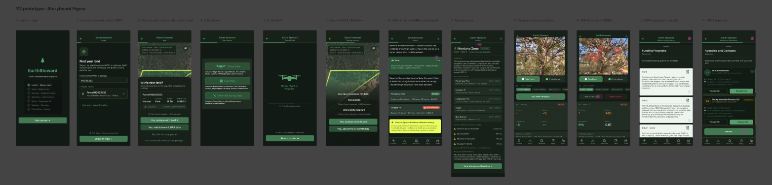
Start at the launch screen and tap through: locate a parcel by APN, confirm it on the map, choose a data source (parcel data, drone or LiDAR), run SAM 3 detection, check the montane life zone, photograph a tree on the ground, and land on an EQIP suggestion with NRCS resources.
Twelve screens, from sketch to Figma
Screens 0–5 are new for V2, built from storyboard page 1. Screens 6–11 carry forward the strongest V1 screens and are being restyled to the V2 library.
- Launch — what the app will walk you through
- Locate — property search by APN
- Map — public county data; confirm this is your land
- Data source — drone, LiDAR or other survey data
- Drone flight — capture in progress
- Review sources — parcel plus drone data, run SAM 3
- SAM 3 map — western spruce budworm and pine beetle
- Montane zone — life zone and key species
- Camera — on-the-ground tree photo
- SAM 3 on tree — budworm detections
- EQIP suggestion — simplified cost-share fit
- NRCS resources — foresters and TSPs who can help
A V2 library built for iOS and the field
The V1 Shadcn-based library was duplicated and reworked so the prototype reads as a native iOS app, not a desktop page squeezed into a phone.
- Earth Steward dark mode as a token set, readable outdoors and consistent across every component.
- iOS standard text sizes and spacing tokens, so Figma and the React build share one scale.
- Purpose-built components: screen template, top nav, flow progress, parcel info bar, source stamp, confidence badge, map placeholder and data-capture options.
- Source stamps on every data point, so a landowner and a forester can see where a number came from and how current it is.
React build and field testing
Next comes a truly mobile React build of this same flow, then testing on iPhone with landowners and foresters, iterating between Build and Test. A key open question is where the forester enters: at the drone or LiDAR choice, or near submission.